
World 🢖 North America 🢖 Central America 🢖 Guatemala
Ancient cities and towns 🢔 Settlements 🢔 Archaeological wonders 🢔 Categories of wonders
Wonder
El Mirador
 In short
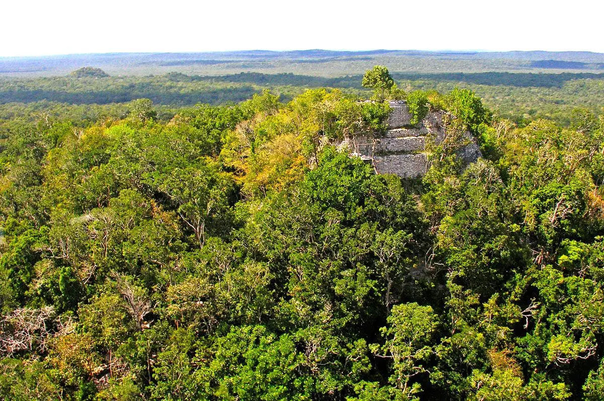
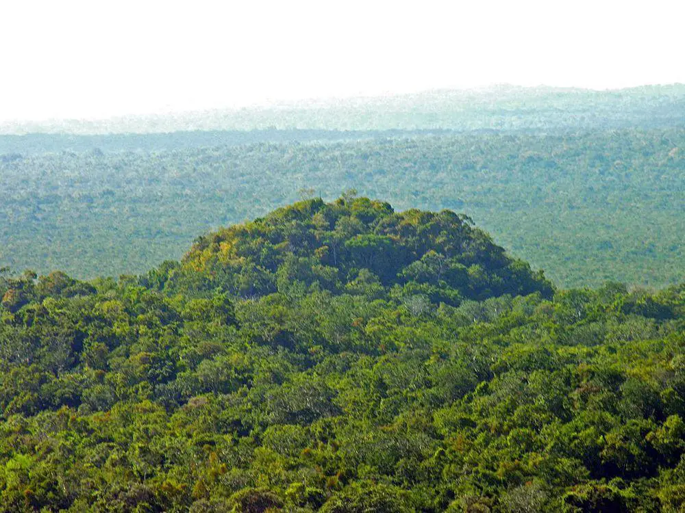
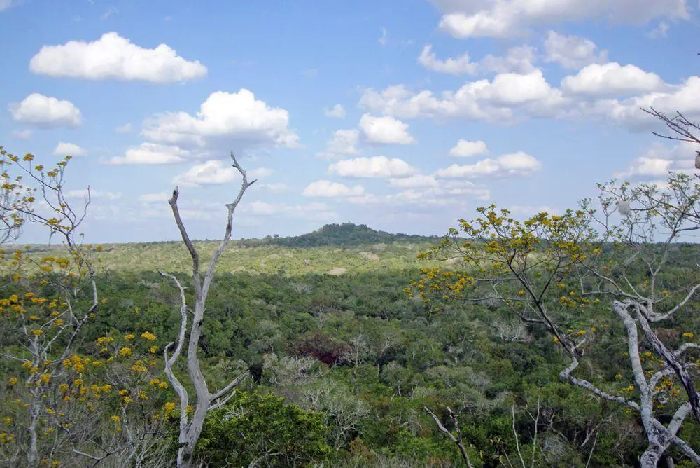
The thick forest cover in the heart of the ancient land of Maya could not cover these giant buildings – even thousands of years after their construction the pyramids of El Mirador rise high above the rainforest. This land is abandoned now – but once upon a time this was the first and largest metropolis of Maya civilization.
 56.7%
56.7%
GPS coordinates
Location, address
Culture
Founded
Flourished
Abandoned
Map of the site
If you see this after your page is loaded completely, leafletJS files are missing.
 In detail
Discovery and research
El Mirador (“observation spot” in Spanish, named after the huge pyramids which provide a sight over the lowland rainforest) was discovered in 1926. As it was located in a very remote place (and there is plenty of other Maya sites keeping scientists busy), researchers did not come here for several decades.
First researcher here was Ian Graham in 1962. More detailed research took place in 1978 – 1983, it was led by Dr. Bruce Dahlin (mapping) and Dr. Ray Matheny (excavations in the center, research of architecture). They were surprised to find that these magnificent ruins are much older than in the nearby Tikal and Uaxactun – the better known Maya cities.
The site and its vicinity became increasingly popular to looters. There was a risk that not much will remain for researchers, thus in 2003 was started an ambitious research project led by Dr. Richard D. Hansen – Mirador Basin Project. (1)
This is not just an archaeological research project. Mirador Basin Project could be comparable to a work of a rather large company, involving many hundreds of people and producing scientific works in different disciplines, marketing their activities, organizing TV broadcasts and press articles, and – reinforcing the remnants of the prehistoric buildings.
Mirador Basin – cradle of Maya civilization?
Mysterious heart of Maya land
It is well possible that the great civilization of Maya originated in so-called “Mirador Basin”. This is the heartland of the great rainforest on the border of Mexico and Guatemala, a depression which in most places is a swampy lowland with low limestone hills.
Numerous – more than 50 – ancient Maya cities have been discovered in this area, most are not explored yet. Hundreds of thousands of people formed this network of cities very long ago, in the Middle and Late Preclassic period of Maya culture, in 300 BC – 150 AD.
Birth of the great Maya cities
Great civilizations are born through hardship when people are forced to join their forces and invent new methods to overcome the forces of nature or seemingly invincible enemies.
Maya were no exception to this. Although they lived in rainforests, there is a pronounced dry period of the year without rain – it lasts from January to May. Densely inhabited areas with hundreds of thousands of people cannot exist in such a climate. Or – they can exist, if people are clever and organized enough to collect the rain and store it in large reservoirs for the dry period of the year.
Maya in Mirador Basin did it sometimes around 300 – 200 BC – there were built complex systems of channels, collecting the rainwater from the large plazas and roofs of the city and channeling it to large reservoirs.
It seems that this newly obtained skill of well-organized public works gave them a huge competitive advantage over the other cultures in the region. A new civilization with strong central administration was born.
Sacbeob
The power of the centralized Maya government is testified by the grandiose system of roads (sacbeob in plural or sacbe in singular) between the cities, and also the lack of large fortifications, which are not needed in the powerful, centralized state.
Sacbeob were straight, leveled paths, built with stone fundament and often rising 3 – 5 m above the surroundings. These roads were 20 – 50 m wide – as wide as a proper motorway. It seems these roads were not just simple to transport infrastructure objects – they might have been built and used mainly for ritual purposes. Mirador Basin could be the first place where such huge road construction took place.
In El Mirador these roads link the largest structures and lead to the other large centers in Mirador Basin of the Middle and Late Preclassic periods. Sacbe from El Mirador to Nakbe is 12 km long, another sacbe to El Tintal – 20 km long.
History of El Mirador
A dense network of cities – a true agglomeration – developed in Mirador Basin and also outside it. Often it is not easy to tell where one city ended and another started.
It seems (not all cities are explored yet) though that El Mirador was larger and more significant than other cities. Here were built the largest structures ever built by Maya and rough calculations show, that in order to inhabit this city and construct its giant buildings there was needed a population of more than 100 000 people.
Rise at 600 BC
El Mirador might have existed as a smaller settlement before – but in the 6th century BC, it turned into an important city. The “golden age” of El Mirador lasted from the 3rd century BC to 150 AD – in this time it was the largest known Maya city and one of ten largest cities in the world. At this time there were built some of the largest structures in the world.
Collapse at 150 AD
An unknown cataclysm happened sometime around 150 AD – cities of Mirador Basin suddenly were abandoned. It seems Maya experienced an enemy attack. Northern, eastern and southern portions of the central part in El Mirador were surrounded by extensive fortification walls which, possibly, were up to 8 m tall. It did not save the city – it was abandoned.
Rebirth
Several centuries and many generations passed before people returned to the city. Approximately at 700 AD, some parts of El Mirador were inhabited again.
This time Maya did not preoccupy themselves with ambitious construction. Among the crumbling giants of the past were built small structures, which did not exceed 8 m in height. Construction stone was taken from the old buildings.
These people were not barbarians – they have left intricate pottery (“Codex-style Ceramics” – now much sought in the black market) and other values of art.
By 900 AD El Mirador was abandoned again. The once beautiful and giant city was covered with rainforest, the heart of civilization turned into a heart of the mysterious forest, rich with the memories about the dreams, ambitions, and accomplishments of a great civilization.
Planning and buildings in Maya metropolis
Planning
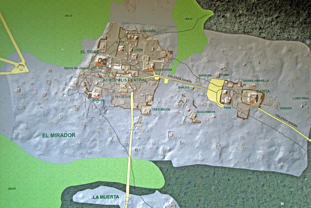
Central part of El Mirador was some 26 km² large.
Like other Maya cities, El Mirador was built according to very strict plans. It is not entirely clear, why the plan looks this way – but it is possible that buildings were carefully aligned for ritual purposes, e.g. to provide a sight towards sunrise or sunset in a certain time of the year.
Structures
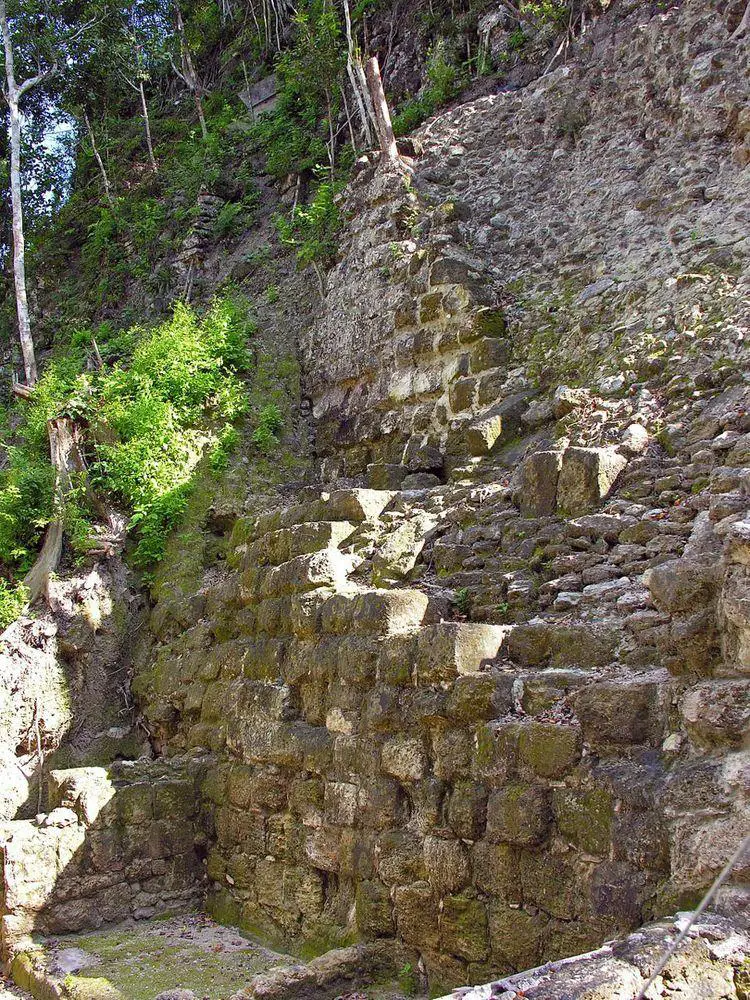
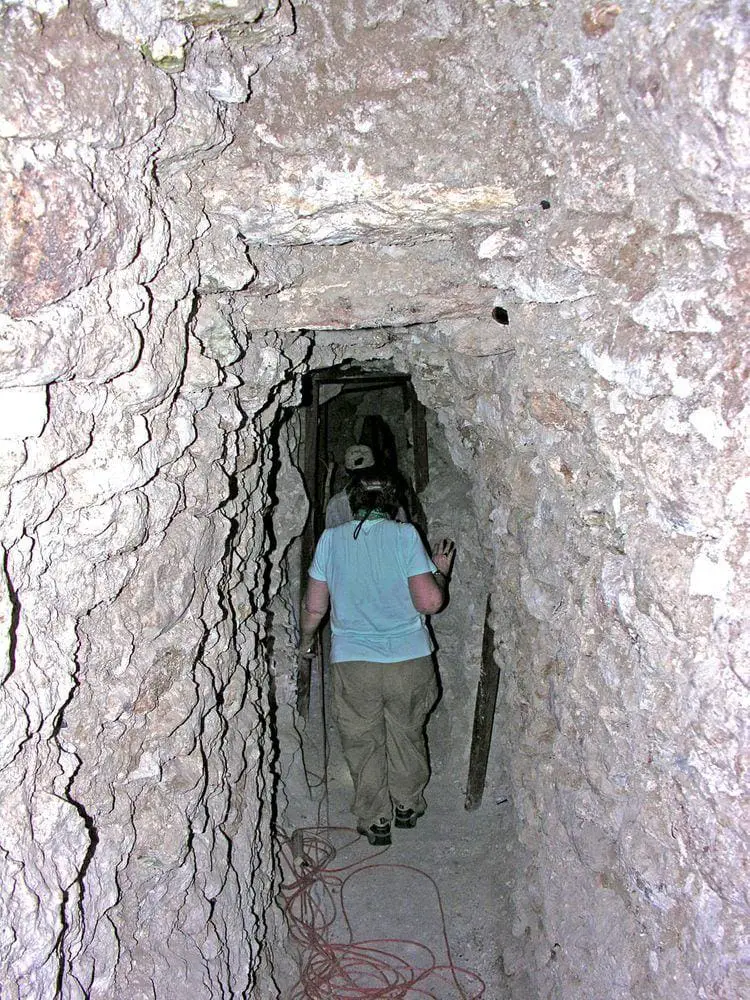
Ruins of several thousands of buildings have been found here. Many buildings are very impressive, some are taller than 30 m (taller than contemporary 10-floor building), buildings have many interesting adornments, even paintings have been discovered in underground structures.
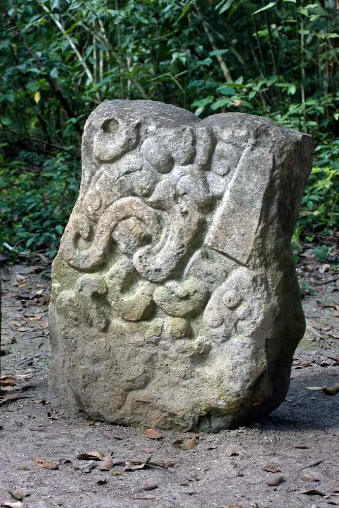
Characteristic feature of local architecture is so-called “triadic” structures – pyramid structures with the main building in the center and two smaller ones at the flanks. Stairways lead up to the top of each pyramid. These buildings originally were adorned with large stucco masks representing the deities of Maya mythology.
In the city are located some 35 such triadic structures, some of them are the largest buildings ever built by Maya. The largest ones are:
- La Danta – the largest Maya pyramid and one of the largest prehistoric buildings in the world. This building stands some 1.8 km to the east from the main group and rises some 70 – 72 m from the forest floor. It is covered with forest, but from the top opens a magnificent view to a seemingly endless forest and other nearby pyramids. The total volume of La Danta is 2.8 million m³ – thus it is one of the largest pyramids in the world – Great Pyramid of Cholula in Mexico has a larger volume of more than 4.4 million m³, but the volume of the Great Pyramid of Giza, Egypt is smaller – 2.5 million m³. La Danta stands on a giant man-made platform, which is 18,000 m² large.
- El Tigre – 55 m tall triadic pyramid, located in supposed centre of city.
- Los Monos – 48 m tall pyramid, also in the centre. This giant structure is little explored.
Many other structures also have been named – Acropolis, Tres Micos, Chicarras, etc. Of special importance was the so-called Structure 34 (Jaguar Paw Temple) in the very center of the city – one of the oldest structures in Mesoamerica, constructed in 200 BC, with an underground passage and some wall paintings remaining. Most buildings are not explored yet.
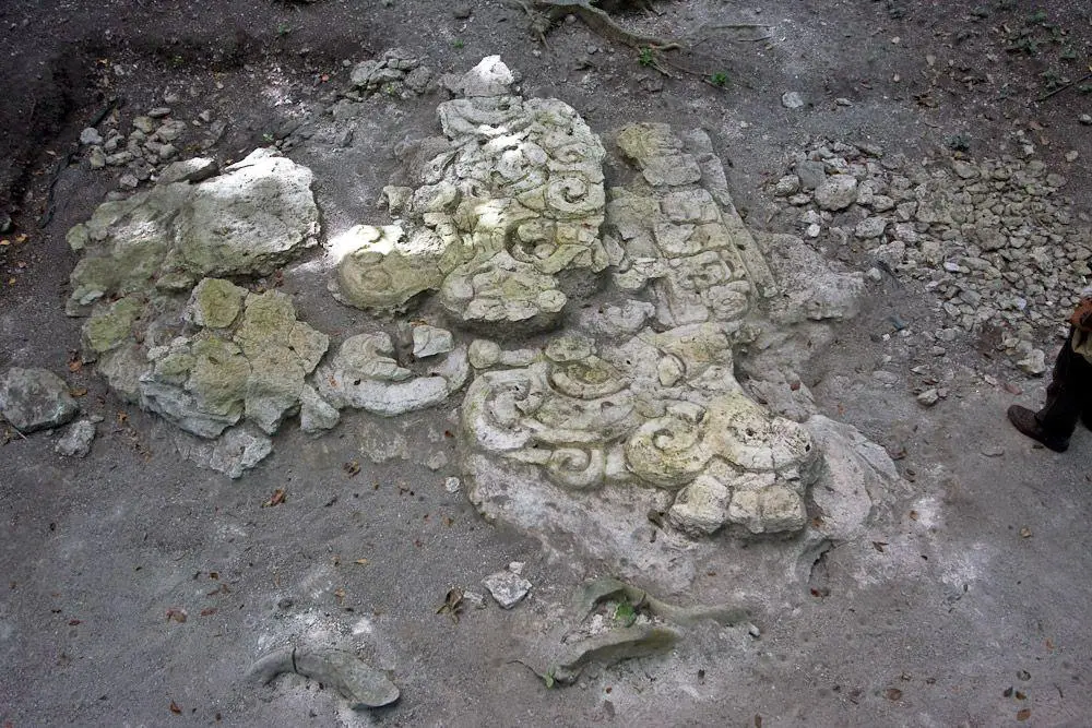
Popol Vuh bas-relief
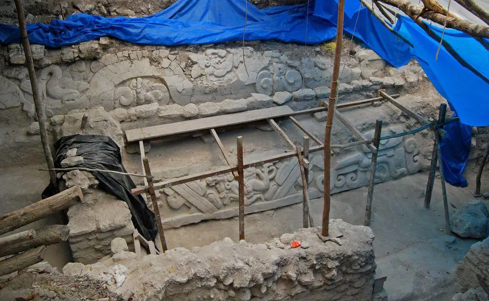
In 2009 there was found large, intricate bas-relief. It adorned the water collection system (a proof of how much revered were these systems) and shows a scene from Popol Vuh – Maya creation myth. Bas-relief is some 4 m long and 3 m high, it shows (possibly) the hero twins Hunaphu and Xbalanque swimming into the underworld to retrieve the head of their decapitated father.(2)
This find redefines the history of Popol Vuh – this great narrative is older than considered before.
Maya Biosphere Reserve
El Mirador is located in Maya Biosphere Reserve. This giant (21 602 km²) protected area takes more than 10% of the area of Guatemala and was established in 1990. It protects the heartland of the ancient Maya civilization and one of the largest rainforests in North America. 513 species of birds and more than 2800 species of vascular plants are known to live here.
Reserve is zoned and includes five national parks. El Mirador is located in one of them – Mirador-Río Azul National Park.
Human activities are encroaching on the park: in the southern part the forest is logged, there are established farms and settlements. El Mirador thus far is not much affected – it stands in the heart of the ancient forest, nearest roads are some 30 km away.
Unfortunately, El Mirador and neighboring cities are suffering heavy losses from the widespread looting of valuables – every month these sites are robbed and art values from these cities end up in auctions worldwide and are sold for millions.
It is planned to turn this remote Maya city into a major tourist destination – tourism might help to decrease the looting by giving the local community an incentive to save the values of the past. Today it is still covered with jungle – and it takes several days of strenuous walk through the jungle to reach it.
References
- Mirador Basin Project. Accessed in 14.07.2012.
- Popol Vuh Relief found in Mirador Basin named one of Top Ten Archaeological Discoveries of 2009, Mirador Basin Project. Accessed in 14.07.2012.
- Mirador National Park. Accessed in 23.07.2018.
- The Logistics of getting to El Mirador (and Nakbé). Site MostlyMaya.com was accessed in 14.07.2012, not available in 2018.
Linked articles
Wonders of Guatemala
The number of exciting landmarks in Guatemala is very high.
By far the most important landmarks in Guatemala are Maya archaeological monuments and the heritage of other Pre-Columbian cultures. Guatemala together with the nearby Mexican states was the cradle of the Mesoamerican civilization – one of the great civilizations in the world.
Ancient cities and towns
It turns out that urban planning is a very old profession. The urban fabric of ancient settlements – their structure and evolution gives a lot of food for thoughts about the nature of humans and civilization.
Wondermondo includes in the category of ancient cities and towns those settlements which have developed as urban areas at least 1500 years ago: around 500 AD.
Abandoned cities and towns
The main impression created by abandoned cities is intimate. This is a mixed feeling of sadness, unclear anxiety (“my city will not be eternal either”), and at the same time – inspiration from the abilities of our ancestors. Long ago, without electricity, paper, or different mechanisms, they managed to create magnificent structures, that covered many square kilometers.
Recommended books
Jungle of Stone

In 1839 rumors of extraordinary yet baffling stone ruins buried within the unmapped jungles of Central America reached two of the world’s most intrepid travelers. Seized by the reports, American diplomat John Lloyd Stephens and British artist Frederick Catherwood—each already celebrated for their adventures in Egypt, the Holy Land, Greece, and Rome—sailed together out of New York Harbor on an expedition into the forbidding rainforest of present-day Honduras, Guatemala, and Mexico. What they found would re-write the West’s understanding of human history.
Lonely Planet Guatemala

Lonely Planet Guatemala is your passport to the most relevant, up-to-date advice on what to see and skip, and what hidden discoveries await you. Visit Tika’s monumental restored temples, learn to speak Spanish while admiring picture-postcard vistas in Antigua, or hike Lago de Atitlan’s lakeshore trails; all with your trusted travel companion.