
Wondermondo 🢖 Lists and articles 🢖 Geysers of Iceland
Publication
Geysers of Iceland
 In short
Some of the world’s most popular geysers are located in Iceland. But few know about ALL active geysers in Iceland.
According to Wondermondo currently (2019) in Iceland could be around 20 – 29 active geysers. It is not easy to count all of them: some geysers might be active but are covered with concrete constructions, others seem to be too small or too similar to perpetual spouters (somewhat less rare landmark – a boiling spring which all the time is shooting up a small fountain). This publication lists also some 38 other places where geysers have existed in the past or features, which are similar to geysers but are not genuine geysers.
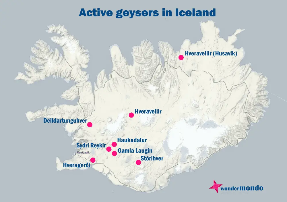
Map of the described existing and former geysers in Iceland
If you see this after your page is loaded completely, leafletJS files are missing.
 Land of geysers
In Iceland are found some of the best-known geysers in the world – and the word geyser itself comes from Iceland. There are at least four geysers or former geysers which are or were named Geysir or Litli Geysir. The root of the name comes from Old Norse "geysa" – to gush, to rush forth. In contemporary Icelandic geyser is named otherwise – “goshver” – “a gushing hot spring”.
Geysers in Iceland are found in a belt that stretches across the island from southwest to northeast. This is a boundary between the Eurasian Plate and the North American Plate, a zone where many geothermal features – volcanoes and diverse hot springs – are observed.
Most geysers of Iceland are short-lived. It is characteristic that Icelandic geysers become more active after earthquakes. Then even new geysers appear in places where they have not been seen before. After some months, years, or decades most of these geysers disappear and in many cases, there is no trace left in the site of a former geyser.
Humans and geysers
Over the last millennia, humans have learned to live together with geysers. Geothermal areas can be dangerous – sometimes eruptions are sudden and violent, sometimes the soil hides treacherous boiling water under it and people may fall in it. But warmth in the hard northern climate is a huge benefit.
Source of heat
Many of the best-known historical farms in Iceland developed next to geysers. Such places are Reykholt, Hveragerði (now a lively town), Útey, Syðri Reykir, and many others. In many places, geysers and even hot springs have disappeared but the farm is still there.
Initially, geysers and other hot springs were used just to cook the food, for washing, and just for everything where hot water is needed. In the 20th century, though far more comfort was achieved, when the hot water with pipes was diverted to nearby farms for heating. Appeared greenhouses and swimming pools but many geysers disappeared – they were covered with concrete structures or disrupted with nearby boreholes.
Tourism
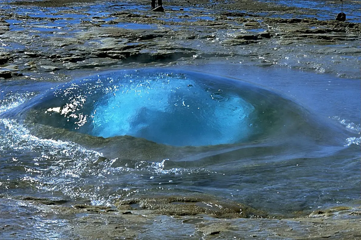
Some geysers, though, brought a benefit through a completely different activity – tourism. For example, seeing the unique Strokkur in action is something unforgettable and nowhere else in the world is seen a similar geyser with a weird bulb of lucid water appearing shortly before the eruption.
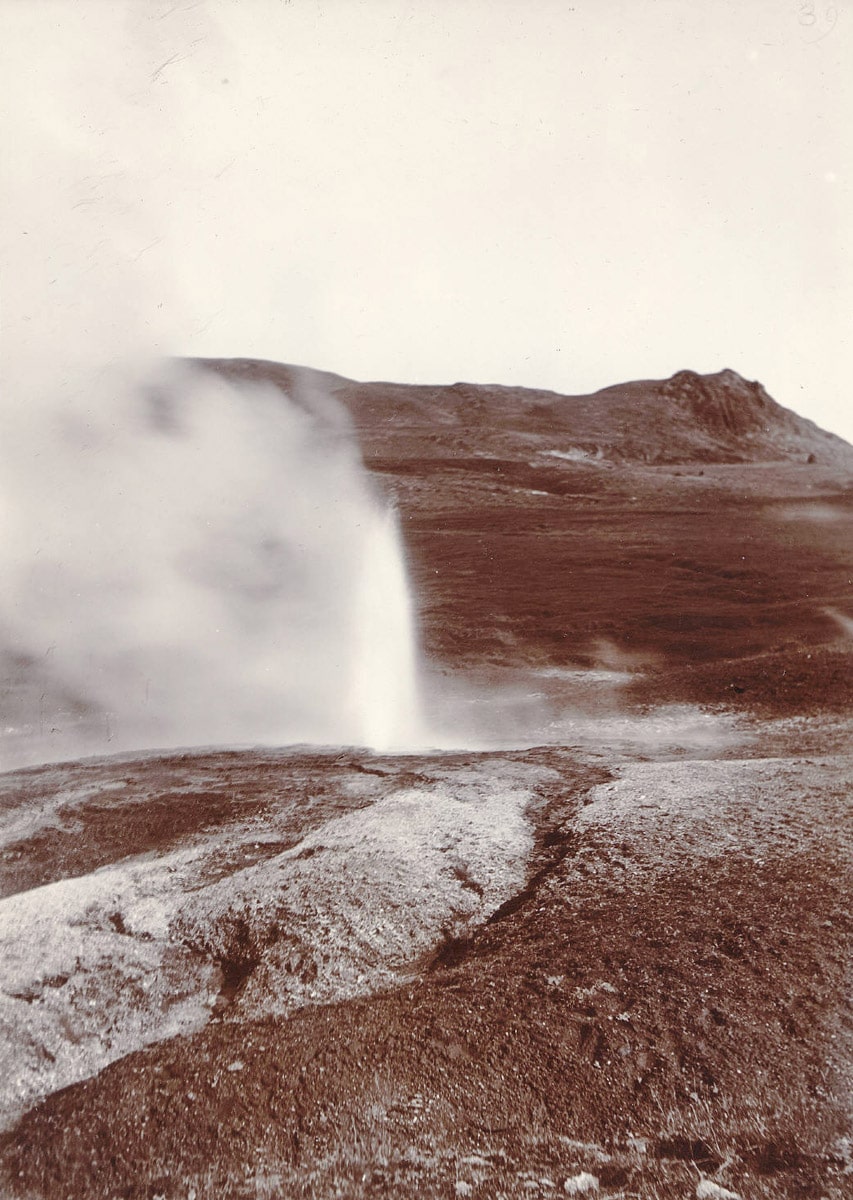
In earlier times some of the most famous geysers were located in Hveragerði town – Robert Bunsen described the physics of geysers after visiting and observing Litli Geysir in Hveragerði, the Great Geyser in Haukadalur, and others. These weird erupting springs were widely known in Europe.
Today most of the tourists visit Haukadalur Geothermal Field and admire Strokkur and other features but many come also to the beautiful Hveravellir Geothermal Field or take the Laugavegur Trail which goes through the Stórihver Geothermal Area.
Largest geysers in Iceland
Today both tallest erupting geysers in Iceland are Strokkur (15 – 40 m) and Geysir (5 – 10 m). The first is erupting on a regular basis while Geysir rarely shows high eruptions. No other geyser in Iceland comes close to this height – there are several geysers erupting 2-3 m high (Ystihver, Stórihver, Deildartunguhver, Grænihver, and Óþerrishola) while others are less high.
In the past several Icelandic geysers were quite impressive. The tallest was Geysir which erupted 120-170 m high! Strokkur also was higher – in the 19th century it was up to 60 m high. Some geysers in Hveravellir Geothermal Area also were quite impressive: Gamli Strokkur was up to 45 m high in the 19th century and nearby Gamli Fagrihver had a similar height. Litli Geysir in Hveragerði was 30 m high and Ystihver – 25 m high as recently as in the 1930ies.
It the list of geysers complete?
Wondermondo did his best to make the list as complete as possible. Nevertheless, in the past in Iceland existed many more geysers than listed here. Thus, in the list of the world’s thermal springs (5.) in the 1960ies are mentioned former geysers near Búðafoss – Wondermondo could not locate any hot springs here today. Much confusion is caused also by the naming of geysers – sometimes one and the same name was used for several nearby geysers which appeared one after another. There are several Strokkurs, Geysirs, Dynkurs around Iceland and not always it is clear which is meant in the reports from the 19th century.
Many geysers existed only for a short while, for some months after the earthquakes. It is very possible that many such geysers were not noticed – some geysers erupt just once per several days or at specific weather conditions (like Óþerrishola) and at the moment of eruption, no one was seeing it.
The same refers to current times: there is a possibility that in less-visited geothermal areas there are some short-lived geysers that have not been noticed by anyone. After all, Iceland, for the most part, is not inhabited and the majority of tourists go the same way.
History continues and also in the future, there will be changes: some geysers in Iceland will become weaker and disappear, some will regain their strength and new ones will appear.
List of the geysers of Iceland
The list below is divided by geothermal areas:
Haukadalur Geothermal Area
Active geysers
| Name | Height | Former height | Description |
|---|---|---|---|
| Strokkur | 15-40 m | 50-60 (19th century) (1.) | One of most popular geysers in the world which forms unique deep blue bulbs of water before the eruptions. |
| Geysir | 5-10 m | 120-170 m | Namegiver to all geysers of the world. Eruptions are very rare, becomes more active after earthquakes. (1.) |
| Óþerrishola | Up to 3 m | 4 m (1930ies) | Conic sinter shield. Rare eruptions, more likely when the atmospheric pressure drops. (1.) |
| Álfaauga | 1 m | ? | Intensely blue spring. Eruptions are rare, activity gradually increases. (1.) |
| “Gey 2” | 1 m (1.) | ? | Could erupt higher, of soap is added – but this is not permitted. (1.) |
Former geysers and other geyser-like features
| Name | Current state | Former height | Description |
|---|---|---|---|
| Blesi | Dormant | 1 m (1897, June 2000) | Beautiful, deep blue spring pool. Geyser activates after earthquakes. (1.) |
| Fata | Dormant | Several metres (active up to 2004) (1.) | Blue spring which turns into geyser after earthquakes. |
| Konungshver | Dormant, nice spring | More than 1 (1896), low (June 2000) | Geyser activated after the earthquake in 1897, disappeared after a year. (1.) |
| Litli Geysir | Rather weak perpetual spouter | 10 (late 19th century) (1.) | |
| Litli Strokkur | Dormant, steaming sinter cone | 9 | Activates after earthquakes. (1.) |
| Seyðirinn | Fumarole (1.) | ? | Could be activated by soap, but this is not alowed here. (1.) |
| Sísjóðandi | Permanent spouter (more than 1 m) with some characteristics of a geyser. (1.) | ? | |
| Smiður | Up to 1 m high perpetual spouter, if activated with soap – 3-7 m. Nice sinter cone. | 3-5 (around 1907) (1.) | Use of soap is not allowed. (1.) |
| Sóði | Dormant, if activated by soap – up to 20 m (1.) | ? | Use of soap is not allowed. Currently cooled down by influx from other springs – thus dormant (1.) |
| Stjarna (Ástarauga) | Extinct | 3.5 (after 1896) | Appeared after earthquake, now disappeared. (1.) |
Deildartunguhver and surrounding areas
Active geysers
| Name | Height | Former height | Description |
|---|---|---|---|
| Deildartunguhver | 3 m | 4 (1810) (1.) | Some three geysers close together. |
| Vellir (Árhver) | 1 m | 11 m | Almost dormant, can be activated with soap – up to 2 m. Unique geyser on an island in the river. |
Former geysers and other geyser-like features
| Name | Current state | Former height | Description |
|---|---|---|---|
| Dynkur (Reykholt) | Under concrete lid, most likely – dormant | ? | Location: 64.66423 -21.288352 |
| Kópareykjahverir | Dormant | ? | |
| Skrifla (Reykholt) | Under rock and concrete lid, most likely – dormant | ? | Location: 64.664565 -21.289221 |
| Strokkur | Dormant | ? | Location: 64.697813 -21.241983 |
| Sturlureykjahver | Extinct | ? |
Hveravellir Geothermal Field
Active geysers
| Name | Height | Former height | Description |
|---|---|---|---|
| Bræðrahver | 1 m | 3 (1888) (1.) | The more active of twin springs, with a sinter cone. Spouter with characteristics of a geyser. The spring is sealing itself and soon may disappear. The other twin spring is Bræðraauga. (1.) |
| Gjósandi | 0.5 m | ? | Formerly called simply Goshver – “geyser”. (1.) |
| Grænihver | 3 m | Most likely new geyser, formerly – a boiling hot spring. | Beautiful, turquoise colored spring, which for most part is fairly calm and only sometimes erupts. (1.) |
| H209g | 1 m | ? | A pool of hot water which is splashing up to 1 m high. (1.) |
| H209n | 0.3 m | ? | Small pool with low splashes. (1.) |
| H210rqs | Low | ? | Very active perpetual spouter which sometimes acts as a true geyser. (1.) |
| H210t | Low | ? | Could be too small even to be considered a true geyser (1.) |
| Meyjarauga | 0.3 m | 3 m | Beautiful, small geyser which is gradually disappearing – drying out. The same name has been used also for some more features in this geothermal field. (1.) |
| Nýi Strokkur (H210a) | 1 m | New | Spouter with characteristics of geyser. (1.) |
Former geysers and other geyser-like features
| Name | Current state | Former height | Description |
|---|---|---|---|
| Bræðraauga | Dormant | 3 m | One of twin springs together with Bræðrahver. Now not connected to its twin and not too active (1.) |
| Eyvindarhver | Extinct? | 0.5 (19th century?) | This spring gradually calmed down – in 1930ies it was a spouter and is one up to now (1.) |
| Gamli Fagrihver | Dormant | 45 m | Major, well known geyser in the 19th century – 1930ies, erupting with the interval of 30 – 90 minutes. (1.) |
| Gamli Strokkur | Extinct | 45 m (19th century) (1.) | Not detectable today |
| Rauðihver | Dormant | 1.5 m (in 2008-2009) | Intermittent spring which turned into a geyser in 2008 and 2009, when it erupted muddy water. (1.) |
Hveravellir (Husavik) Geothermal Field
Active geysers
| Name | Height | Former height | Description |
|---|---|---|---|
| Ystihver | 3 m (with soap – 10 m) | 25 m (1930ies) | In the 19th century was not too active, but in 1904 the activity was boosted by artificial lowering of the water level. (1.) |
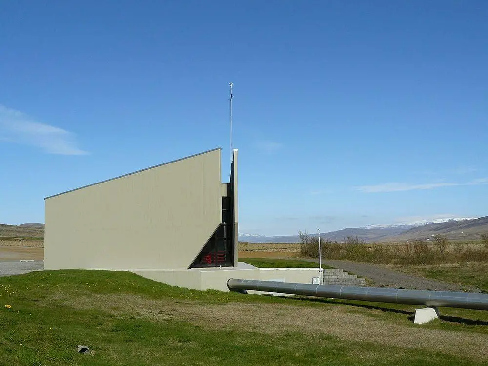
| Uxahver | Covered with concrete, most likely active | 9 m (19th century) | The most significant geyser in this group in the 19th century. Covered with a concrete roof in 1970. (1.) |
Former geysers and other geyser-like features
| Name | Current state | Former height | Description |
|---|---|---|---|
| Syðstihver | Dormant | 3 m | Covered with a concrete roof. |
Geothermal areas around Hveragerði town
Active geysers
| Name | Height | Former height | Description |
|---|---|---|---|
| Eilífur | Several metres | New | Possible artificial geyser? “Inaugurated” in 2016. |
| Geyser south from Spýtir | 0.2 – 0.5 m (4.) | New | Exact location. Boiling spring with 3×4 m large basin, with geyser in the middle. (4.) |
Former geysers and other geyser-like features
| Name | Current state | Former height | Description |
|---|---|---|---|
| Baðstofuhver | Extinct | 7-15 (before 1800) (1.) | |
| Bogi I | Extinct | ? | Artificial. Was active in 1930ies due to piping created by the landowner Bogi Þorðarson (1.) |
| Bogi II | Extinct | ? | Artificial. The same as previous. |
| Dynkur | Steam vent | Above 0.3 m | During the eruption was ejecting a fine spray (1.) |
| Geyser next to Baðstofuhver | Extinct | Above 0.3 (1930ies) (1.) | Eruption took place every 7 – 15 minutes. |
| Gosi | Extinct | 4 m | Erupted every 2 hours, geyser stopped to erupt around 1937. (1.) |
| Gosi II | Extinct | Above 0.3 m | Some meters southeast from Gosi. Erupted up to around 1940, usually erupted were shortly before Grýla (1.) |
| Grýla | Dormant or extinct | 10 (up to 1970ies) (1.) | |
| Leppaluði borehole | Artificial, with soap 10-12 m | – | |
| Litli Geysir | Extinct | Up to 30 m (after and earthquake in 1829) (1.) | Erupted every 3 hours and 45 minutes. Described by Robert Bunsen in 1846. Activity ended in the second half of 19th century. (1.) |
| Önnuhver (Ruslahver) | Dormant | Several metres (1947) | Became active after an earthquake in 1947, throwing out all the garbage which was thrown in it. (1.) |
| Spýtir | Extinct | 0.5 m | This may be was not a geyser but an impressive bubble shower spring with 5 cm large bubbles (1., 5.) |
| Geyser NE from Spýtir | Extinct | 0.5 m | Was active in the 1930ies, when it erupted every 80 seconds. (1.) |
| Svaði | Extinct | Significant, several metres | This was a very powerful geyser of muddy water. In 1941 was some 1.5 m high. (1.) |
| Tungarðshver | Extinct | 2 m | Just north from Litli Geysir. Active in 1883 but soon after activity ended. (1.) |
Stórihver Geothermal Area
Active geysers
?
| Name | Height | Former height | Description |
|---|---|---|---|
| Stórihver | 2 – 3 m | ? | Emits an impressive plume of steam. |
| Kátur | ? | ? |
Krysuvik – Seltun Geothermal Area
| Name | Current state | Former height | Description |
|---|---|---|---|
| Nýihver | Dormant | ? | |
| (borehole) | Actively erupting | Not a true geyser |
Gamla Laugin
Active geysers
| Name | Height | Former height | Description |
|---|---|---|---|
| Litli Geysir | Around 1 m? | Might be new | Only recent information. Erupts every few minutes. Artificial? |
Gunnuhver Geothermal Area
Former geysers and other geyser-like features
| Name | Current state | Former height | Description |
|---|---|---|---|
| Hverinn 1918 (Reykjanes Geyser, Litly Geysir?) | Extinct | 12 m (in 1967) | Formed in 1918 or 1919. The only salt geysers in Iceland, fed by the seawater. One geyser was to the northeast from viewing platform, another – to the southeast. (6.) Reactivated after the earthquake in 1967. (2.) Human activities terminated the geyser in 1983. (1.) |
Other geysers and possible geysers
Active geysers
| Name | Height | Former height | Description |
|---|---|---|---|
| Syðri Reykir | Unknown because covered with concrete | ? | Most likely active. |
Former geysers and other geyser-like features
| Name | Current state | Former height | Description |
|---|---|---|---|
| Hveramoahver | ? | Was active geyser until 1950ies (1.) | Possible location: 64.032004 -21.197262 |
| Eruptions in the southern part of Kleifarvatn lake | ? | ? | There are several hot springs on the lake bed and from time to time their gushes break through the lake water. (1.) |
| Former geyser in Útey | Hot spring | ? | One of hot springs here earlier (before 1930) was a geyser. (4.) Approximate location at 64.202637 -20.697337. |
References
- Dirk Niermann. Volcanic Springs. The Geysers of Iceland.
- Kristján Jónasson og Sigmundur Einarsson. Jarðminjar á háhitasvæðum Íslands Jarðfræði, landmótun og yfirborðsummerki jarðhita, 2009. ISSN: 1670-0120.
- Lesbók Morgunblaðsins, 4 February, 1995.
- M.M. Tharanga, N.B. Munasinghe. Geothermal Exploration in Gufuldalur, Hveragerdi, SW-Iceland. Geothermal Training Programme, Reports 2013, Number 21. ISSN: 1670-7427
- Gerald A. Waring. Thermal Springs of the United States and Other Countries of the World – A Summary. 1965.
- Kristján Sæmundsson. Gunnuhver – hot springs. Iceland Geosurvey.
Recommended books
ICELAND, waterfalls, volcanoes, glaciers, canyons, hot springs, lakes, geysers, craters, lava fields: Smart Travel Guide for Nature Lovers, Hikers, Trekkers, Photographers

This is a unique and the most complete “smart” travel guide, which I made, at first, to be solely used on my own, after buying so many travel guides and still feeling – they aren’t good enough for my adventures to explore the wilderness as a biologist and wildlife/travel photographer. I was missing it during my 4 expeditions in ICELAND, 2015-2018, otherwise, I would be much more efficient as a landscape/wildlife photographer and traveler.
The Laugavegur Trail

The Laugavegur Trail is thorough, but a lighthearted guide to Iceland’s most famous and popular backpacking trek. The guide provides you with all the logistical information you will need to plan and execute your hike while also providing beautiful, annotated panoramas, basic maps, and anecdotal stories that provide great insight and regional context for the journey. The book is complimented well by the Serkort #4 (Landmannalaugar Fjallabak) 1:100,000 topographic map.