
Geysers 🢔 Geothermal features 🢔 Geological wonders 🢔 Categories of wonders
Wonder
Strokkur
 In short
Currently Strokkur ("the churn") belongs to the most spectacular geysers on Earth. But not always it has been like this – sometimes around 1900 it seemed to be extinct.
 62.0%
62.0%
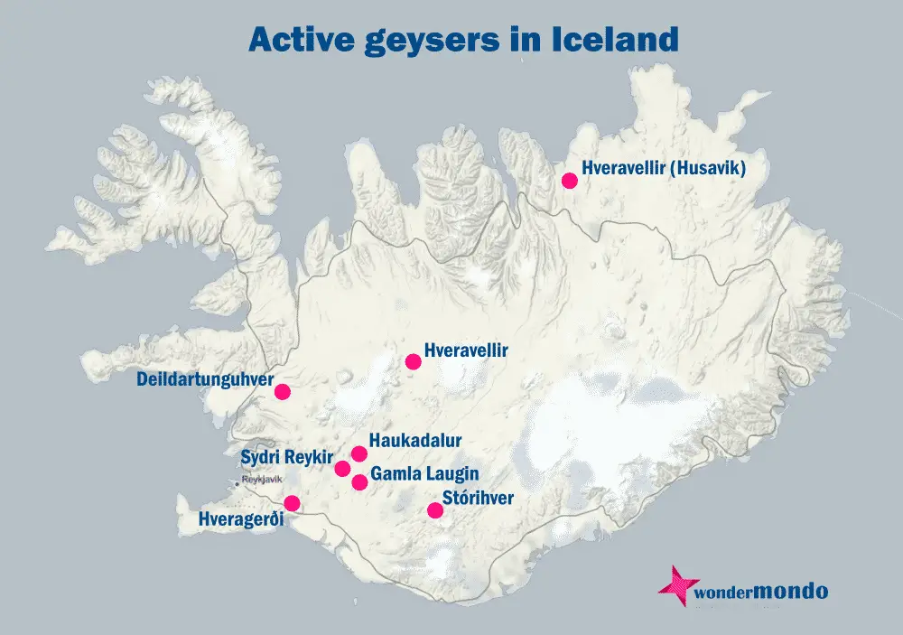
GPS coordinates
Location, address
Height
Map of the site
If you see this after your page is loaded completely, leafletJS files are missing.
 In detail
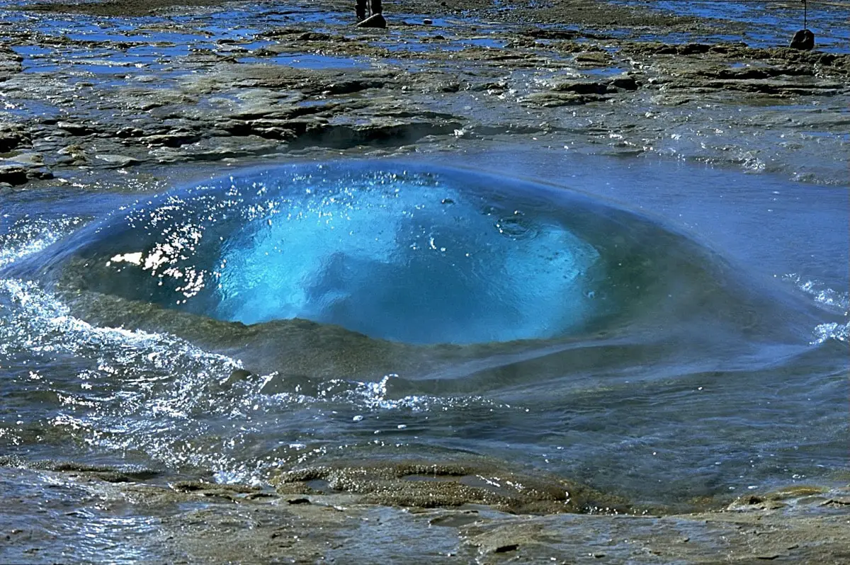
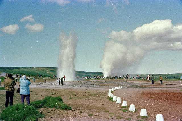
Photogenic eruptions
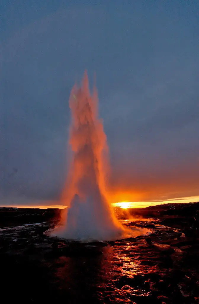
Strokkur is the main attraction in the beautiful Haukadalur geothermal area.
In fact this is the only reliable geyser in this famous geyser field. Every few minutes it forms some 10 – 20 m tall fountain, first starting with an unique bubble. Sometimes fountain is even 40 m high.
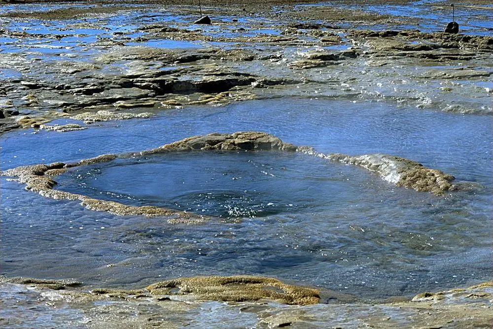
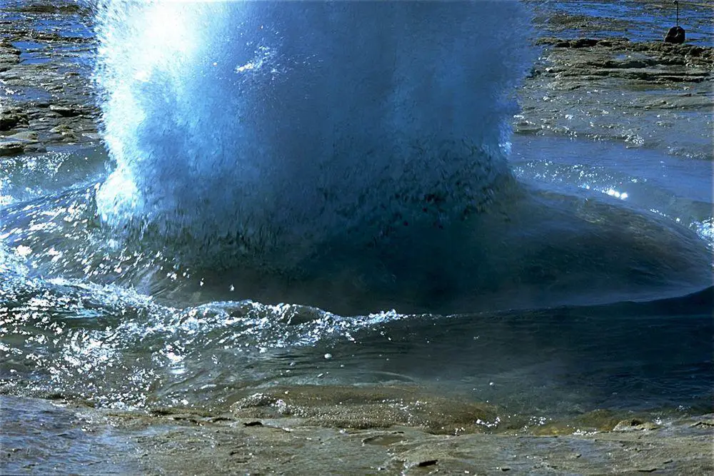
After the eruption the pool of geyser is emptied – but it quickly (even in 10 seconds) fills up. Before the eruption the pool is pulsating up and down and then a pulse of steam pushes the water upwards, forming a weird bubble with steam visible through it!
The steam breaks the bubble and eruption starts. For most part there is one powerful burst, but there may happen several bursts as well.
Changing activity
Although now Strokkur is very active, not always it has been like this.
This geyser was first noticed in 1789, when after an earthquake it was erupting up to 40 m high.
According to reports of several scientists the power of eruptions fluctuated in the 19th century. In 1810 George Mackenzie reported that Strokkur is some 20 m high and eruptions were lasting for half an hour. In 1815 Henderson estimated that it is even 60 m high. Professor Bunsen in 1846 estimated it to be 50 m high. At the end of the 19th century geyser increased its activity.
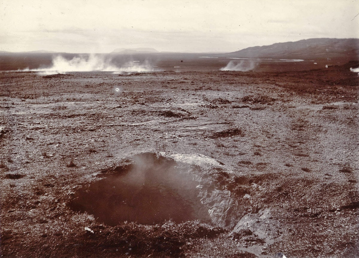
Earthquakes at the turn of the 20th century made Strokkur silent – just a steaming hole wit water deeper in it remained.
It remained like this until 1963 – then the vent was thoroughly cleaned with a drill up to 40 m depth through the bottom of its basin (as advised by Geysir Committee). This action was very successful – since this time Strokkur is the main attraction in Haukadalur, with its spectacular and frequent eruptions visible from afar.
References
- Suzan Pasvanoglu, Hrefna Kristmannsdóttir, Sveinbjörn Björnsson, Helgi Torfason, Geochemical Study of the Geysir Geothermal Field in Haukadalur, S-Iceland, Proceedings World Geothermal Congress 2000. Accessed on July 12, 2011.
- Robert Allan, On the condition of the Haukedalr Geysers of Iceland, July, 1855.
Webcam!
- Míla Webcamera with both Geysir and Strokkur visible, accessed on July 15, 2011. Looks great!
Strokkur is included in the following article:
Linked articles
Wonders of Iceland
Iceland is very rich with peculiar natural landmarks and the island contains also interesting cultural landmarks. The highlights of Iceland are the magnificent waterfalls as well as geysers and other geothermal features.
Geysers
Hasty hydrogeologists would say: geysers are thermodynamically and hydrodynamically unstable hot springs. “Normal” people would say – geysers are hot springs that at more or less regular intervals shoot up a fountain of boiling water and steam. Sometimes these fountains are even 100 m tall… or even 450 m!
Springs
Powerful natural freshwater springs belong to the most fascinating monuments of nature. Even more exciting is the diversity of unusual springs – mineral springs, hot springs, submarine springs as well as the unusual black smokers. Especially beautiful are such natural rarities as travertine, silica, or salt terraces created by warm and hot springs and, especially, geysers.
Recommended books
Iceland Travel Guide

Iceland Travel Guide Introduction This book includes all the necessary links for an easy journey to your Icelandic adventure. To make your Iceland travel more entertaining and full of all of the things that you want, you’ll see a step-by-step route around the entire country, indicating the distance in miles, accommodations, recreation, entertainment, shopping, and much more. This Iceland travel guide will be the perfect companion to see all of the hottest spots, like Blue Lagoon, Iceland, and other must-sees.
The Glorious Geology of Iceland’s Golden Circle

This is the first book describing the glorious geology of Iceland’s Golden Circle and four additional excursions:(1) the beautiful valleys and mountains of the fjord of Hvalfjördur, (2) the unique landscape and geothermal fields of the Hengill Volcano, (3) the explosion craters, volcanic fissures, and lava fields of the Reykjanes Peninsula, and (4) the volcanoes (Hekla, Eyjafjallajökull, Katla), waterfalls, sandur plains, and rock columns of South Iceland. The Golden Circle offers a unique opportunity to observe and understand many of our planet’s forces in action.